PAGASA sees good weather starting Monday
Posted 6 years ago

MANILA — Weather bureau PAGASA sees good weather returning to the country by Monday as typhoon Ompong moved towards southern China.
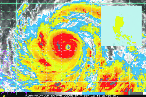
In a press briefing at 5:06 a.m. on Sunday, PAGASA senior weather specialist Gener Quitlong said Ompong maintained its strength of 145 kilometers per hour (kph) maximum sustained winds with gustiness of 180 kph.
At 4 a.m., the eye of Ompong was 480 kilometers west northwest of Laoag City, Ilocos Norte (outside of the Philippine Area of Responsiblity).
It was forecast to be 1,215 kilometers west of Basco, Batanes (outside PAR) by Monday morning.
“With this development and unless re-entry occurs, this is the final warning for this weather disturbance,” PAGASA said.
Quitlong said the typhoon could still get stronger before hitting landfall near Hong Kong, China.
Ompong was still having an impact on coastal waters, which is why gale warnings were still up, he said.
PAGASA advised that fisherfolks, especially those with small seacrafts, should still not venture out over the northern and western seaboards of Luzon.
Quitlong said Luzon would still have cloudy weather on Sunday, and blamed the typhoon’s cloud band for the rain still being experienced in parts of the country.
In its 5 a.m. Severe Weather Bulletin for Ompong, PAGASA said: “The Southwest Monsoon (Habagat) enhanced by the typhoon will bring occasional gusty winds and scattered light to moderate to at times heavy rains over Western Visayas, MIMAROPA, Ilocos Region, Batangas, Bataan, and Zambales.
“Residents in these areas, especially those living near river channels, in low-lying areas and in mountainous areas, are advised to take appropriate actions against possible flooding and landslides, coordinate with local disaster risk reduction and management offices, and to continue monitoring for updates.”
Quitlong said the country would experience good weather for 2 to 3 days starting Monday.
source: abs-cbn.com


Loading Comment